 ← All stories
 Photographing Val d'Orcia without clichés
Yes, the lone cypress. But also: backroads, late-afternoon mist, and why dawn beats sunset.
Yes, the lone cypress. But also: backroads, late-afternoon mist, and why dawn beats sunset.
What you're actually photographing
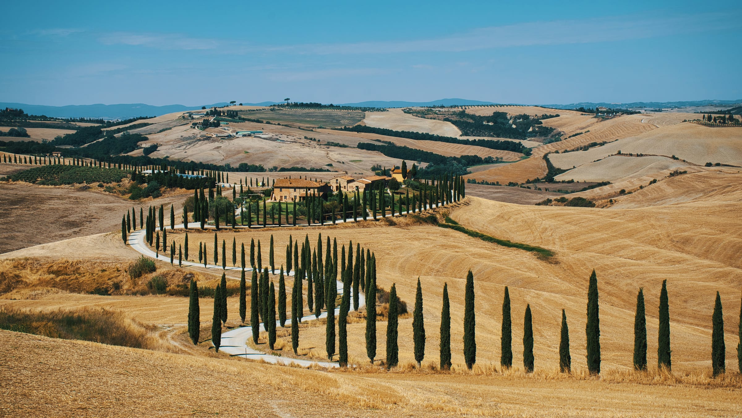
Val d'Orcia is a 70 square-kilometre valley in southern Tuscany, UNESCO-listed in 2004 specifically because it represents the Renaissance ideal of cultivated agricultural landscape — the kind of view 15th-century painters used as backdrops for the Virgin Mary. The visual signature is consistent: gently rolling clay hills (the Crete) ploughed in concentric stripes, occasional single cypresses on hilltops, narrow white gravel roads, isolated stone farmhouses, and avenues of cypress trees lining the entrances to old country estates.
The classic shots — Cipressi di San Quirico, the lone cypress hill at Cipressino, the curving avenue at Baccoleno — exist on a small enough geography that you can photograph all of them in one day if you push. But the better trip slows down and works the backroads instead.
Why dawn beats sunset
Sunset is when 90% of photographers arrive. The same three pull-offs (Cipressi di San Quirico, the Vitaleta chapel, Belvedere di San Quirico) fill with rental cars by 6pm in May–October. You'll fight for tripod position with twenty other people shooting the same frame.
Dawn does three things better. First, the valleys fill with low-lying mist between 5:30am and 7:30am in spring and autumn — sometimes a complete sea of cloud below 300m that you can only photograph from above. The light at first golden hour is warmer than evening (eastward-facing valleys catch the first rays directly). And you'll have almost any vantage to yourself.
The practical schedule. Sleep in Pienza or San Quirico. Set an alarm for 60 minutes before sunrise (around 5:00am in late May, 6:30am in October). Drive to your chosen location with headlights on; many of the back-roads are deeply unlit. Shoot for 90 minutes. Be back in town for breakfast by 9am.
The four signature locations
Cipressi di San Quirico (the cypress avenue). SP146, 5km east of San Quirico d'Orcia. Park at the small lay-by; the avenue runs perpendicular to the road. Best in low side-light — late afternoon if you must do sunset, dawn if you can. Coordinates: 43.05°N, 11.61°E.
Cipressino (the lone cypress hill). SP14 between Pienza and Monticchiello. The single cypress on the hill summit is the most-Instagrammed tree in Italy. Best at dawn with mist below. Coordinates: 43.06°N, 11.69°E.
Belvedere di San Quirico (Cappella della Madonna di Vitaleta). A small chapel at the top of a cypress-lined gravel road, with the whole Val d'Orcia spread out behind it. Shoot from the SP146 ridge looking down. Coordinates: 43.07°N, 11.62°E.
Agriturismo Baccoleno cypress road. North of Asciano on the SP60. A curving white-gravel road lined with cypresses that climbs to a farmhouse. Photographed from the air or from the hill opposite. Coordinates: 43.20°N, 11.55°E.
Working the backroads
The four signature spots above are crowded. The Val d'Orcia is at its best when you skip them and drive the backroads between San Quirico, Pienza, Castiglione d'Orcia and Bagno Vignoni. Park anywhere. Walk 10 minutes in any direction. You'll find a frame nobody else has.
Three under-shot routes:
SP53 between Pienza and Monticchiello. Narrow ridge road with views into the valleys on both sides. Stop at the Capannelle ruins (km 4); the view east is one of the great Tuscan panoramas.
The Crete Senesi south of Asciano. SS451 → SP60. Lunar-looking clay hills, rare single cypresses, an entirely different visual character to the cultivated Val d'Orcia proper. Best in late winter when the clay is bare.
The road from Bagno Vignoni up to Rocca d'Orcia. SP323. Switchbacks, a ruined fortress at the top, almost no other cars even in October. The view from Rocca d'Orcia summit takes in three valleys at once.
When weather matters more than time of day
A flat blue sky over the Val d'Orcia produces postcard images. The pictures that work for editorial use are the ones with weather. Three conditions to wait for:
Low overcast with breaks of sun. The shadows of cloud passing across the hills give the landscape its shape. Spring and autumn afternoons after a storm are particularly good.
Mist below 300m. Dawn after a cold autumn night. The valleys fill with cloud while the hilltop villages and the higher cypress avenues sit above it. Pienza, Montichiello and Castelluccio are all good vantage points.
Storm light. The hour before or after a thunderstorm. The contrast between black cloud and golden hills is what painters tried to capture. Common in May, August and September afternoons.
Seasons
Late February to mid-March. Bare ploughed clay. Hardest light for amateur photographers; best light for editorial work.
April–May. Green fields, wildflowers, ploughed contours still visible. Most photogenic month for the classic Val d'Orcia look.
June. Fields turn golden as the wheat matures. The famous yellow-fields-with-cypress shots are mostly June.
Late June through mid-July. Harvest. The fields go from gold to brown stubble within a 10-day window. You can drive past the same field three days running and see it transformed.
Late September to late October. Second growth, new ploughing, golden light, lowest crowds. Often the editorial-photographers' month.
Winter. Mist common, snow on the higher hills 3–5 times each winter. Atmospheric and underphotographed.
Gear and practicalities
What you actually need. A tripod (the dawn light is too low for handheld), a 24–70mm zoom (covers all the signature shots), a 70–200mm zoom (for the compressed cypress + hill compositions), a graduated ND filter (the dawn-mist scenes have a huge dynamic range), and a head torch for the pre-dawn walk to your spot.
Drones. Val d'Orcia is a UNESCO site. Drone use is restricted — check the ENAC drone-area maps before flying. Most photographers have moved to handheld 70–200mm shots from elevated vantage points as a workaround.
Respect. The cypress avenues are private property; the road is public, the avenue is not. Don't walk between the cypresses. The farmhouses are working farms; don't enter driveways without permission.
Where to base. Pienza (most options, central) or San Quirico d'Orcia (closer to the SP146 cypress avenue, quieter). Agriturismi in the valley itself if you want zero light pollution for night-sky photography.
Read next. Our Siena region pillar covers the wider province; the seven-day Chianti itinerary includes the Val d'Orcia approach.
Frequently asked.
- What's the best time of day to photograph Val d'Orcia?
- Dawn beats sunset for the iconic cypress shots. The valleys fill with mist below 300m elevation in the hour before sunrise; by 8am the mist has lifted and the light goes flat. Sunset brings crowds and harsher shadows.
- Where is the famous Tuscan cypress road?
- The most-photographed cypress avenue (the Cipressi di San Quirico) is on the Strada Provinciale 53, 5km east of San Quirico d'Orcia. Park at the small lay-by; the avenue runs perpendicular to the road. There's also the Agriturismo Baccoleno cypress road north of Asciano, and the lone cypress hill near Pienza.
- Do I need permission to photograph the cypress avenues?
- No — they're on public roads and visible from public ground. But the avenues themselves are private property; don't walk between the cypresses. Drone use is restricted in Val d'Orcia (UNESCO protected); check Enac drone-area maps before flying.
- Which season is best for Val d'Orcia photography?
- Mid-September through October for golden light on harvested wheat fields. May for green fields and wildflowers. Avoid August (heat haze, midday light, brown fields). Winter brings mist and snow on the higher hills — atmospheric but unpredictable.